Our Past Projects
Informing Marine Spatial Planning for the Coral Sea Natural Park of New Caledonia

On 23 April 2014, the Coral Sea Natural Park was officially established by the Government of New Caledonia, covering approximately 1.3 million km² of maritime territory and ranking among the largest protected marine areas globally. Recognized as a biodiversity hotspot with high endemism, New Caledonia includes deep‑sea, pelagic, and coral reef ecosystems with rich evolutionary heritage. The park’s management framework is structured around 15 objectives within four pillars: natural and cultural heritage protection; sustainable and responsible use; good governance; and local, regional and international integration. Despite this, a comprehensive marine spatial planning (MSP) process has not yet been applied at the full scale of the CSNP—making it an ideal candidate for such planning. Commissioned by the Pew Bertarelli Ocean Legacy initiative in New Caledonia, our mission focused on designing a full network of protected areas in the CSNP through demonstrative zoning scenarios combining the park’s management goals with ecological, biological, traditional and environmental knowledge. This work evaluates various management approaches to identify new high‑protection areas, inform best‑practice spatial planning and provide evidence to shape the CSNP’s next management plan.
Nature-based solutions for climate action, biodiversity, and people in the United Arab Emirates

This project is led by Emirates Nature-WWF (EN-WWF) in partnership with Environment Agency Abu Dhabi (EAD), the International Centre for Biosaline Agriculture (ICBA) and funded by HSBC. The goal of the four-year project is to test and implement nature-based solutions (NbS) in the United Arab Emirates to address climate change mitigation challenges, promote biodiversity and create opportunities for socio-economic co-benefits. The project is focused on coastal ecosystem-based management and restoration addressing technical, policy and financial aspects with relevance to government and private decision makers. The results will guide decision making towards a policy framework that unlocks political support and financing for NbS to address a range of key national and global policies. Workstream one of this EN-WWF led project conducted a rapid and broad scale multi-criteria site selection process to identify and rank planning units on their suitability for delivering successful outcomes from NbS (Pittman et al. 2021, Pittman et al. 2022). Two high scoring seascapes from the stakeholder-led model) were selected as demonstration sites for implementing NbS. Workstream 2 (currently in progress) conducted an ecosystem services (ES) assessment for the two demonstration seascapes using InVEST (Integrated Valuation of Ecosystem Services and Tradeoffs) as a spatial modeling tool (Arkema et al. 2015). Effective ecosystem services assessment to inform the design and evaluation of nature-based solutions requires diverse spatial and aspatial data spanning three broad themes:
1.) biophysical environment;
2.) biodiversity and species distributions; and
3.) human uses, infrastructure, and potential threats
Enhancing social-ecological resilience and ecosystem services through restoration of coastal agroforestry systems in Hawaiʻi

Agroforestry systems have the capacity to support resilient coastal communities through providing food, conserving native biodiversity, and supporting multiple ecosystem services, and represent growing priorities for conservation initiatives worldwide. Yet, there is a paucity of data on costs and benefits of agroforest restoration and little guidance on where these systems are most likely to provide valued ecosystem services, such as carbon sequestration and sediment retention, alongside food production. This project builds on a biocultural agroforestry restoration project in Heʻeia, Oʻahu designed in collaboration with the community-based non-profit Kākoʻo ʻŌiwi. We work at the farm and ahupuaʻa scale in Heʻeia to better understand the ecological, economic, and cultural outcomes of coastal agroforestry restoration through time and combine this experience with agroforestry producer interviews and environmental, social, and economic data sets to develop scenarios of agroforesty restoration options relevant across the State. Based on this, we identify hot spot priority areas that can enhance biodiversity and ecosystem services of high interest to agencies, funders, and communities across the state including local food production, non-timber forest products for market and subsistence use, carbon sequestration, and/or supporting resilient coral reef ecosystems through reducing sediment export. Collectively, this research aims to improve the evidence base of agroforestry and help to match potential incentive programs, such as carbon offsets, with agroforest ecosystem service hotspots that provide multiple benefits and support resilient communities. We will also draw upon our collective experience to organize a workshop for undergraduate students, graduate students, and post-docs focused on participatory, community-based research or co-production of knowledge through the lens of enhancing ecosystem services and community resilience through agroforestry restoration.
Investing in Resilience: Blue Carbon Ecosystems, Communities, and Finance for the Indo-Pacific
"Investing in Resilience: Blue Carbon Ecosystems, Communities, and Finance for the Indo-Pacific"

Human activity and climate change are threatening ecologically, economically, and culturally important blue carbon ecosystems throughout the Indo-Pacific region. These losses have cascading effects on nature, people and economies.
Climate change also threatens the viability of coastal economies and livelihoods, reducing critical habitat for ecologically and economically important fisheries and increasing the risk of overfishing as fish populations decline. Loss of blue carbon ecosystems imposes disproportionate impacts on women, girls, indigenous people, people with disabilities, and other marginalized groups.
These groups have less access to information and resources to adapt their livelihood strategies, they are often excluded from decision making processes, and their livelihood activities are often undervalued or overlooked in standard economic and market analyses. USAID is bringing together a team of global experts on fisheries, natural capital, carbon markets, and community-level climate risk management, who will examine the latest science, community perspectives, and innovative financing strategies to help governments, the private sector, and communities accelerate responsible investment in blue carbon ecosystems.
With an initial focus on the Indo-Pacific, the team is conducting:
-
An inventory carbon sequestration by mangrove forests, seagrasses, and other less examined blue carbon ecosystems across the Indo-Pacific, and estimate losses of these habitats due to human activities;
-
Analyzing the ecological and economic risks that blue carbon losses pose to Pacific communities, and identify opportunities to restore and conserve blue carbon through nature-based solutions and community capacity building; and
-
Assessing public and private sector opportunities and mechanisms for scaling financing for blue carbon initiatives, and developing a financing handbook tailored to Indo-Pacific countries.
Asia Development Bank - Natural Capital Specialist

Nearly all ADB’s developing member countries (DMCs) heavily depend on natural capital (e.g., land, water, forest, renewable energy and marine resources) for their socioeconomic growth, especially in their rural areas. However, natural capital has been underdeveloped, over-exploited or polluted in recent decades. The associated ecosystems have become increasingly more fragile and susceptible to climate change. Weakening ecosystems pose direct threats to food, nutrition and livelihood security, and trap many rural households in prolonged poverty. To cope with these persistent challenges, ADB is in the process of establishing a “Natural Capital Lab (NCL)”, to assist DMCs in monitoring and valuing dynamic changes in natural capital and to design and improve strategies, policies, incentivize programs and support projects to promote natural capital conservation and investments. These efforts will generate and strengthen transformational community-oriented solutions and ecosystem-based measures for climate change adaptation. Jade was hired as a Natural Capital Specialist to identify interlinkages among natural capital, ecosystem services and development in the context of Sri Lanka, along with developing training material and a framework for environmental accounting to make practical recommendations in enhancing natural capital investment.
Photo:
Credit : www.shutterstock.com
Ike Wai

Our team collaborated with the University of Hawaii ‘ike Wai project. The project mission is to ensure Hawaiʻi’s future water security through an integrated program of research, education, community engagement, and decision support. Its vision is to promote water resource management in Hawaiʻi that is sustainable, responsible, and data driven. Scientific, cultural, and social dimensions to the problem of water security are integrated in a transparent, stakeholder-driven, and rigorous water research enterprise. From this collaboration came several publications.
Photo: Copyright: Design Pics / Greg Vaughn
Uncovering the effects of tourism on the fishery of Hāʻena

This project seeks to quantify observed changes in the fish community in Hāʻena, Kauaʻi to the road closure resulting from the extreme flood event in April 2018 and more recently the cessation of tourism due to COVID-19. The perception of the community is that fishes in the area, particularly fishery species, became more abundant in response to the reduction of tourist activity in nearshore waters. To address this question, we have conducted surveys of fish abundance, behavior, and benthic (coral and algae) cover, and human use beginning in 2018.
Informing conservation from ridge-to-reef in Vanuatu

Expansion of coastal development, along with wastewater discharge and fertilizers, can harm coral reefs and their fisheries through increases in sediment and nutrient runoff. Consequent reef degradation directly affects ecological resilience, food security, human well-being, and cultural practices in tropical island communities around the world. To determine where management on land can most effectively support current community-led efforts to restore reef health and abundance in Vanuatu, we built a fine-scale, linked land-and-sea modeling framework that integrates existing land-use with coral reef condition and fisheries health and applied it at the regional scale using existing datasets and the local scale with models calibrated by field data we collected.
Pūpūkea Coral and Fish Assessment: 2010 - 2019
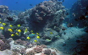
The State of Hawaii created the Pūpūkea-Waimea Marine Life Conservation District (MLCD) on the north shore of the island of O‘ahu in 1983 (and expanded in 2002) to conserve the unique ecological resources of the area and to allow for public interaction with the marine environment. Scientific monitoring of fish and benthic communities in the Pūpūkea-Waimea MLCD has occurred over the years since its expansion with the most recent comprehensive surveys occurring in 2010. At the request of Malama Pūpūkea-Waimea (a non-profit community organization that conducts outreach and monitoring) Seascape Solutions replicated the 2010 surveys inside the MLCD in order to 1) evaluate changes in coral cover and 2) quantify changes in coral reef fish assemblages over time at Pūpūkea-Waimea MLCD
Ka‘ūpūlehu Marine Reserve Comparison of Targeted Fish Behavior

Ka‘ūpūlehu is located on the west coast of Hawai‘i island. The Nature Conservancy Hawai‘i (TNCH) partnered with the Ka‘ūpūlehu community to help establish the Ka‘ūpūlehu Marine Reserve which went into effect on July 29, 2016. The rule establishes a 10-year no-take “rest period” (with limited exceptions) to allow for the recovery of reef fish stocks. Following the rest period, a fishery management plan (to be developed) will be implemented for Ka‘ūpūlehu. This analysis of the effect of protection on fish behavior was based on data collected in partnership with TNCH. It complements data collected by TNCH on fish assemblage metrics in the same areas, during the same time periods.
Seascape models reveal places to focus coastal fisheries management

To design effective marine reserves and support fisheries, more information on fishing patterns and impacts for targeted species is needed, as well as better understanding of their key habitats. We developed a set of fishing effort and habitat layers at high resolution and employed machine learning techniques to create regional-scale seascape models and predictive maps of biomass and body length of targeted reef fishes for the main Hawaiian Islands. By comparing current targeted fish distributions with those predicted when fishing effort was removed, areas with high recovery potential on each island were revealed. Spatial protection of these areas would aid recovery of nearshore coral reef fisheries
A linked land-sea modeling framework to inform ridge-to-reef management in high oceanic islands

Declining natural resources have contributed to a cultural renaissance across the Pacific that seeks to revive customary ridge-to-reef management approaches to protect freshwater and coral reef fisheries. Effective ridge-to-reef management requires improved understanding of land-sea linkages and decision-support tools to simultaneously evaluate the effects of terrestrial and marine drivers on coral reefs, mediated by human activities. To address this gap, we developed a linked land-sea tool, which coupled groundwater and coral reef models at fine spatial resolution, to determine the effects of terrestrial drivers, mediated by human activities, and marine drivers on coral reefs.
Place-based management can reduce human impacts on coral reefs in a changing climate
We applied a linked land–sea tool, which couples groundwater nutrient export and coral reef models. This spatially explicit tool simultaneously tracks changes in multiple benthic and fish indicators as a function of community-led marine closures, land-use and climate change scenarios. We applied this framework in Ha‘ena and Ka‘upulehu, located at opposite ends of the Hawaiian Archipelago to identify priority areas on land where upgrading cesspools can reduce human impacts on coral reefs in the face of projected climate change impacts.
Scenario planning with linked land-sea models inform where forest
conservation actions will promote coral reef resilience

We developed a linked land-sea modeling framework based on remote sensing and empirical data, which couples sediment export and coral reef models at fine spatial resolution. This spatially-explicit (60 × 60 m) framework simultaneously tracks changes in multiple benthic and fish indicators as a
function of land-use and climate change scenarios. We applied this framework in Kubulau District, Fiji, to investigate the effects of logging, agriculture expansion, and restoration on coral reef resilience. We evaluated where land-use change and bleaching scenarios would impact sediment runoff and downstream coral reefs to identify priority areas on land, where conservation or restoration could promote coral reef resilience in the face of climate change.